


Boatie app for iPhone and iPad
Developer: Mojoso
First release : 09 May 2012
App size: 70.02 Mb
Boatie is an invaluable source of information for all who enjoy recreational boating in UK and Irish coastal waters. Developed and used by a keen sailor, after 14 years it remains the popular choice and go-to app of thousands.
Features:
• Port display for approx. 750 primary and secondary ports from the United Kingdom, Channel Islands, Isle of Man and the Republic of Ireland. This gives you a tide table for the next 7 days, along with a meteogram of 3 hourly weather forecasts and daylight times, position relative to closest springs or neaps and moon phase. For 648 ports, there is a tidal curve prediction for the current day. Both are extendable up to 10 days with the 10-Day Tidal Curves subscription. With the curves you can see the height predicted for any time - or visa versa (default behaviour configurable in Settings) and optionally a curve adjusted for barometric pressure.
• View Tide Tables in a standard format, and with an enhanced subscription retrieve up to 12 months of data (where available) for a port.
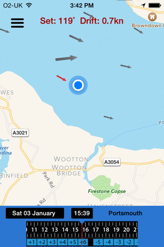
• Tidal Streams for up to 10 days (more than 7 days requires the 10-Day Curves subscription). Pan and zoom the map to show your preferred area, and scroll along the time. Touch and hold to see the forecasted set and drift. This data covers the UK coastline except the north of Scotland, Outer Hebrides, Orkneys and Shetland Isles (i.e. roughly north of the Caledonian canal)
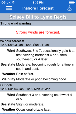
• Marine Forecasts:
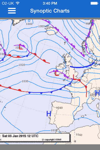
- the current UK Inshore and Shipping forecasts, and synoptic charts for Northern Atlantic and NW Europe.
- the current Irish Sea Area Forecast and Coastal Report.
• Navigation:
- display your current GPS position, speed-over-ground, course-over-ground, as well as distance and heading to user-configurable waypoints.
- Waypoints can be imported or exported as GPX files and ordered within the file to allow quick switching to the next waypoint.
- A built-in compass shows the direction to the current waypoint.
- **New Experimental Features** Available with all subscription tiers except Basic and can be enabled from the Settings page.
- A navigation view to display the contents of a selected waypoint file plotted on a map. Create a track to a waypoint and calculate cross track error (XTE) with heading correction plus Velocity Made Good.
- Navigation Narration - with a waypoint target set, Boatie can now narrate key navigation data such as BTW, SOG, COG, VMG-C, Heading, DTW and XTE. Useful when needing to use Boatie ‘hands-free’ .
• Reference: a useful set of information easily to hand whether youre out on the water or doing your theory course. It currently includes:
- Day shapes
- Navigation lights
- Sound signals
- Beaufort scale
- Forecast terminology
- UK Inshore forecast areas map
- ROE Marine Weather Services Map
- Signal flags, phonetic alphabet & morse code
- VHF Channel usage plus emergency radio protocols
- IALA A Buoyage
- Links to UKHO Alerts
• Widgets, a companion Apple Watch app and Complications are included.
So, next time you are meeting the crew in the pub for planning your weekend, or when youre out enjoying it, take Boatie to have the key information you need with you on your iPhone or iPad.
An internet connection is required for some features, although the data is then cached for short periods for use whilst out sailing.
*** Note: There is no longer an up-front payment to download the app, however a subscription is required to access the service. ***
Please do let me know your feedback - Im always very grateful it. If you have questions, find problems or have suggestions for future improvements please use the facilities in the app or email [email protected] .
Boatie - Terms & Conditions: https://msswsolutions.com/boatie-terms-and-conditions/
Apple EULA: https://www.apple.com/legal/internet-services/itunes/dev/stdeula/